


NEW ORLEANS — Hurricane Ida swept toward the Louisiana coast as a strong Category 4 storm Sunday morning, up from a Category 2 storm on Saturday evening, with landfall expected midday between Grand Isle and Port Fourchon.
The National Weather Service in New Orleans on Sunday morning issued an extreme wind warning and urged residents to prepare “as if a tornado was approaching” and seek shelter immediately.
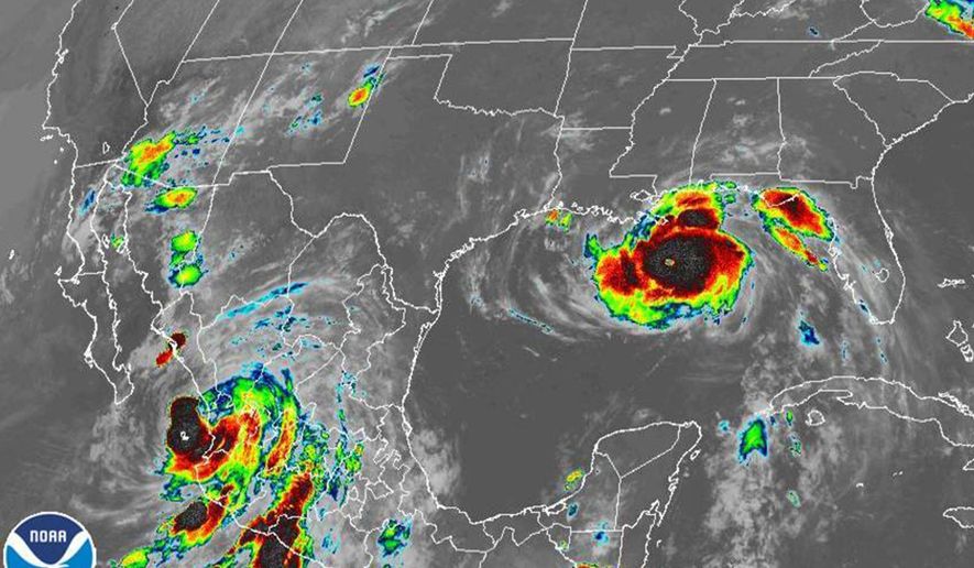
Hurricane trackers with the National Ocean and Atmospheric Administration were aloft over the storm in the Gulf of Mexico and recorded gusts up to 166 mph around 9:30 a.m., although authorities reported sustained gusts of around 115 mph. That left open a small possibility Ida could reach Category 5 status before it lands.
Ida is poised to be the most dangerous storm to hit New Orleans since Katrina, which slammed home on this same date in 2005.
High winds are expected to swirl throughout southeastern Louisiana into Sunday night as residents prepped as best they could for extended power outages. Shortly before 10 a.m., television meteorologists began to warn residents they should shelter in downstairs rooms with as few windows facing the storm as possible and to brace doors with overturned tables or mattresses.
A significant flood surge is also expected to wash over the coast east of Houma all the way to the Mississippi Gulf Coast.
Ida’s “eye” jiggled a bit to the east as most residents slept Saturday night, meaning the city woke up Sunday to a storm’s most menacing centerline, one that heads up just west of New Orleans. Hurricanes churn counter-clockwise and locations east of the eye suffer the most intense damage.
Ida also strengthened, as NOAA hurricane trackers confirmed when they were finally able to get aloft and above the storm. Reports from the storm planes showed Ida would become just the fifth Category 4 storm to strike Louisiana since they began recording them.
The sustained wind and clusters of intense activity that swarm around the eastern rim of the hurricane’s eye also raised concerns that spot tornadoes could spin out as the storm passes through the area, a process that is expected to continue through Sunday night.
Ida’s might and the anniversary left thousands of residents afraid the system’s levee system, rebuilt after its disastrous failure during Katrina, will falter in its first huge test. The new levee system is designed to withstand up to a slow-moving Category 3 storm, and authorities have warned that some levees may overtop Sunday, a less-catastrophic development than Katrina’s breakage that flooded New Orleans.
It remained unclear how many people may have evacuated the area, although anecdotal evidence suggests considerable numbers of New Orleanians chose to ride out the storm at home. Residents outside the protected levee zone faced a mandatory evacuation that began Friday, and the system’s flood gates rolled shut around 6 p.m. Saturday.
Flights in and out of New Orleans were canceled Sunday and the causeway that connects the north and south shores of Lake Pontchartrain was slated to close at 11 a.m. local time. Police began urging motorists to stay off the roads Saturday, warning that increased Sunday as patrol stops were set up in multiple parishes to stop any cars found traveling.
Please read our comment policy before commenting.